IAC News
IAC News Special Issue No.10. December 19, 2016
Japan Society of Civil Engineers International Activities Center December 19, 2016 IAC News Special Issue No.10
Quick Report on the 2016 Kumamoto Earthquake
On April 14, 2016, a magnitude 6.5 earthquake occurred, centered in Kumamoto Prefecture and registering the maximum intensity of 7 on the Japanese scale in Mashiki Town. On April 16, there was another earthquake, with a magnitude of 7.3, which registered an intensity of 7 in Mashiki Town and Nishihara Village, and caused enormous damage throughout Kumamoto Prefecture. This was followed by frequent aftershocks, the number of which was the highest ever recorded, and they showed no signs of subsiding as of May. According to the records observed at KiK-net Mashiki, in the main shock on April 16, the peak ground acceleration in the EW direction registered 1157 gal (Fig. 1), and the maximum velocity registered 127 kine (Fig. 2). Its seismic motion exhibited massive destructive power comparable to that registered in the 1995 Hyogoken-Nanbu Earthquake. The Japan Society of Civil Engineers (JSCE) sent an emergency investigation team from the West Branch and investigation teams from the Earthquake Engineering Committee and the Geotechnical Engineering Committee to assess the damage. This report provides a quick summary of the investigation results.

Fig. 1: Acceleration time history of the main shock observed at KiK-net Mashiki

Fig. 2: Speed time history of the main shock observed at KiK-net Mashiki (High Pass Filter: 0.05 Hz)
Damage to bridges
Bridges of the Kyushu Expressway and Prefectural Highway 28 and in the Minamiaso region were severely damaged.
On the Kyushu Expressway, the piers of the Kiyamagawa Bridge and Akizugawa Bridge, which had been reinforced against earthquakes, were not damaged; however, most of the steel bearings were damaged, and beams were displaced from the bearings, causing an uneven road surface. Also, several overbridges were damaged. The Furyo Overbridge collapsed onto the expressway following the main shock early on the morning of April 16 (Photo 1).
On Prefectural Highway 28, there were several damaged bridges that had been built based on design standards established after the 1995 Great Hanshin-Awaji Earthquake. On the Okirihata Bridge, which is a five-span continuous bridge, rubber bearings were broken at every abutment and pier, except for one pier (Photo 2), and as a result, beams moved in the bridge-axial rectangular direction, and reinforced concrete bridge piers with unbroken bearings suffered bending damage. Additionally, on the Tawarayama Bridge, there was displacement of beams from the rubber bearings and buckling of steel beams.
In the Minamiaso area, the Aso-Ohashi Bridge collapsed and was carried away downstream due to slope failure (Photo 3). On the Minamiaso Bridge, which had been reinforced against earthquakes with dampers, parts mounted with dampers working in the bridge-axial direction were damaged.
The investigation of damaged bridges indicated that in many cases, proactive measures such as the installation of a collapse prevention system had worked; on the other hand, however, there were also cases in which a structure with lateral displacement constraints was destroyed, exposing its weakness. These investigation results call for further study of measures to be taken against the collapse of superstructures.

Photo 1: Collapse of Furyo Overbridge onto the Kyushu Expressway
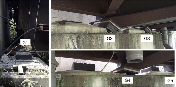
Photo 2: Abutment of Okirihata Bridge with broken rubber bearings

Photo 3: Collapse of Aso-Ohashi Bridge due to slope failure
Damage to stone bridges and the ruins of Kumamoto Castle
These two earthquakes, the foreshock and the main shock, both of which had a seismic intensity of 7, devastated many of the stone bridges in Kumamoto Prefecture and the ruins of Kumamoto Castle. These included the Tsujunkyo Bridge (constructed in 1854), which is a nationally important cultural property, the Nagayama Bridge (1878) and Tatekado Bridge in Kikuchi City, which are designated as cultural property by Kumamoto Prefecture, and the Yasemegane Bridge (1885) and Monzengawamegane Bridge (1808) in Mifune Town, which are also designated as cultural property by Kumamoto Prefecture. On these bridges, stone walls collapsed and arch stones were damaged. On the face of the Tsujunkyo Bridge, a significant number of cracks with a width of 5?10 cm occurred in the covering soil between the stone wall and the stone pipe portion, and as a result, the upper part of the stone wall swelled outward (red circle in Photo 4). It was also found that gaps had developed at many of the joint parts of the stone water pipes, and extensive damage and flaking were found in the plaster parts, indicating possible water pipe damage. These findings show that further investigation is needed to clarify the damage status of the water pipes. The photos of Shimotsuru Bridge (Uki City, Photo 5) show the collapse status of the masonry wall and bridge railings (Photo above), the wide gaps that developed between the arch stones and the cracking of those stones (Photo below). The development of gaps between the arch stones was found to be very similar to the arch stone behavior observed in a vibration experiment using an arch stone model. According to the report, however, the collapse of arch stones did not occur in these major earthquakes. Typical types of damage include collapse and swelling of stone walls and falling of bridge railings. On the other hand, major damage occurred in the ruins of Kumamoto Castle (Fig. 3) including the complete collapse of Kitajuhachiken-Yagura, Higashijuhachiken-Yagura, Goken-Yagura, Akazunomon and Nagabei, which are nationally important cultural property, damage to 26 structures such as turrets (yagura) and gates, and the collapse of stone walls. Damage was found at 52 locations, and much of it was caused by the main shock.

Photo 4: Deformation of the upper part of the stone wall of Tsujunkyo Bridge


Photo 5: Collapse status of the masonry wall of Shimotsuru Bridge (Uki City) and gaps that developed between the arch stones

Fig. 3: Major damage to the ruins of Kumamoto Castle (Article from May 8 Morning Edition of Kumamoto Nichi Nichi Shimbun)
Landslide disasters
The 2016 Kumamoto Earthquake caused landslides in Oita Prefecture, Saga Prefecture, Nagasaki Prefecture, Miyazaki Prefecture and Kagoshima Prefecture as well as in Kumamoto Prefecture; the total number of landslides has not yet been determined. According to the disaster information from the Ministry of Land, Infrastructure, Transport and Tourism (MLIT), however, the number of landslides was 125 as of May 13, and 94 of them occurred in Kumamoto Prefecture. There were ten victims (one missing person included), who were killed by mud avalanches. Many landslides occurred in the area including Minamiaso Village, where seismic motion was strong, and it is assumed that most of the landslides occurred early on the morning of April 16, when the main shock hit this area.
The landslide disasters in the earthquake were mostly characterized by ground collapse at areas where the surface layer consisted of volcanic ash soil. The following are major examples of the collapse: (1) It is assumed that large-scale slope failure (deep-seated landslides) (Photo 6, 7) occurred when a massive vibration hit the slope that had a weak plane, which had formed under the influence of weathering acting on the lava with cracks developed in the surface layer of volcanic ash and the basement stratum. Since the upper part of the area where the collapse occurred was steeply inclined, the massive vibration hitting that part caused cracking, leading to the collapse of the surface layer. It is considered that this collapse caused the collapse of the weathered lava layer, which is believed to have supported the surface layer, thus resulting in the large-scale collapse. (2) This was the collapse of a slope with a gradient of less than 20° (Photo 8). There was a very weak stratum (Photo 9), which had formed through the argillation of pyroclastic fall material, beneath the relatively thick volcanic ash soil layer (kuroboku soil/akaboku soil). When hit by the massive vibration, the weak stratum became fluidized and slid off a flattened basement stratum, the Kusasenrigahama pumice layer, resulting in a large-scale mass failure. It is considered that this was the collapse of volcanic ash soil layers and pyroclastic fall material including very few boulders. (3) As shown in the surface failure on Mt. Eboshidake (Photo 10), in the area around the central cone, volcanic ash soil layers of the steeply inclined slope collapsed in a continuous manner, resulting in a great amount of collapsed sediment. Some of the soil fell into mountain streams and caused mud avalanches; however, most of the soil fell into streams and remained there (Photo 11), raising concerns about more disastrous mud avalanches after a heavy rain or intense rainstorm during the rainy or typhoon seasons in the future. Furthermore, in any type of slope collapse, large cracks are found on the top or side of the upper parts of the area where the collapse occurred, which shows that further slope collapse can take place at any time. (4) As shown in the picture of the road leading to Aso Choyo Ohashi Bridge, roads collapsed and were damaged (Photo 12). This road collapse appears to have been caused by the collapse of volcanic ash soil on lava, since the inclination of the collapsed part is gentle. Also, collapse and damage of the road constructed in the steeply inclined area near Aso Choyo Ohashi Bridge were remarkably severe (Photo 13).
Many small-scale slope failures also occurred, and a great amount of soil collapsed into the same mountain stream, and it remains on the slopes or in the stream, threatening to cause mud flows and devastation of the downstream area after a heavy rainfall. Considering the current situation, and since it takes a lot of time to prepare the hardware aspects of disaster-prevention measures, presently it is most important to enhance the software aspects of measures among the local people so that they can escape disaster immediately and save their own lives. Furthermore, since deformation such as cracking has developed in some places of the slopes in the areas hit by intense quakes, it is necessary to stay on the alert against slope collapse.

Photo 6: Large-scale slope failure that caused the collapse of Aso-Ohashi Bridge

Photo 7: Collapsed sediment and rock mass deposited on gently inclined area

Photo 8: Surface failure that occurred on a gently inclined slope

Photo 9: Weak argillaceous stratum, the layer that caused the landslide, had formed in the lower part of the akaboku soil stratum. The Kusasenrigahama pumice fall deposit can be seen under this layer.

Photo 10: Surface failure on the south slope of Mt. Eboshidake

Photo 11: Collapsed sediment blocked the outlet of a valley, downstream of which is the Sannodani River.

Photo 12: Collapse of the road leading to Aso Choyo Ohashi Bridge

Photo 13: Damage and collapse of the access road connected to Aso Choyo Ohashi Bridge
Damage to lifelines
The earthquakes on April 14 and 16 brought about severe damage to lifelines such as electricity, gas and water supply (Fig. 4). About 200,000 households temporarily lost power, and as of the night of April 16, about 80,000 households were still without power, which was recovered by April 20. Regarding water supply, up to 370,000 households were without water until one week later when water could be supplied to 90% of the households; however, about 4,000 households were still without water as of May 10. City gas supply was suspended for about 100,000 households, but was gradually restored from April 20 and then completely restored by the end of April. Also, many general waste disposal facilities, which are closely linked to daily life, were damaged. Due to damaged combustion furnaces, four garbage disposal facilities were unusable for a prolonged time, making it difficult to dispose of disaster waste. As shown in Fig. 5, the number of evacuees, which once exceeded 180,000, decreased with the restoration of water, gas and electricity supply; however, about 10,000 people were still living in 251 shelters as of May 11.
Traffic-related facilities were also severely damaged. On the Kyushu Expressway, the section between the Ueki Interchange and the Yatsushiro Interchange was closed to traffic, but the entire expressway reopened on April 29. In addition, many roads including National Routes 3 and 57 and other highways were closed to traffic due to damage such as sediment disaster and road collapse. The transportation infrastructure was badly damaged, which also affected public transportation. After the derailment of an out-of-service passenger train, operation of the Kyushu Shinkansen was suspended, and then all other JR Kyushu train services were also suspended in the prefecture. The Minami Aso Railway was severely damaged by landslides, and presently it is not clear when the line will resume normal service. Kumamoto Airport was closed due to the collapse of ceilings in the terminal building and all flights were canceled, and due to the damage to the movable bridge in Kumamoto Port, all ferry services were canceled. All express bus services and all regular bus services except for those in the Arao City area and the section between Arao and Tamana were canceled, and Kumamoto City Streetcars and Kumamoto Electric Railway suspended operations. The Shinkansen line partially resumed service on April 20, and service on the entire line resumed on April 27. Kumamoto Airport resumed operations on April 19, and Kumamoto Port on April 22. Kumamoto City Streetcars partially resumed service on April 19 and service on the entire line resumed on April 20, and Kumamoto Electric Railway partially resumed service on April 20 and service on the entire line on April 23. Regular bus services and JR train services have been progressively resumed.
City halls and town halls, which can also serve as disaster-prevention centers, became unusable. Photo 14 shows the city hall building of Uto City, in which the fourth floor of the five-story building nearly collapsed. Also, Yatsushiro City Hall, Hitoyoshi City Hall, Mashiki Town Hall and Ozu Town Hall became unusable and could not serve as disaster-prevention centers. Additionally, foundation hospitals including Kumamoto City Hospital were not able to take critical-care patients due to damage to buildings and interruption of electricity, gas and water supply, which brought about confusion at medical sites. Such damage to the disaster-prevention centers hindered assistance for those affected.

Fig. 4: Restoration status of city gas, electricity and water supply (number of households without gas, electricity and water supply)

Fig 5: Changes in the number of evacuees and shelters

Photo 14: City hall building of Uto City
Finally, we express our heartfelt condolences to the families of the victims of the series of earthquakes centered on the Kumamoto region, and our sincerest sympathy for all those affected by the disasters.
Acknowledgment:
This report was prepared based on the seismic motion records provided by the Kiban Kyoshin network (KiK-net) of the National Research Institute for Earth Science and Disaster Resilience (NIED). We take this opportunity to express our sincere gratitude.
References:
(1) Japan Society of Civil Engineers (JSCE)-West: Emergency disaster report on the 2016 Kumamoto Earthquake (First report-tenth report)
(2) Investigation Results of the 2016 Kumamoto Earthquake (Materials for Preliminary Reports)
(3) Ministry of Land, Infrastructure and Transport (MLIT): Disaster Information on Earthquakes Centered on the Kumamoto Region of Kumamoto Prefecture (35th Report) http://www.mlit.go.jp/common/001131315.pdf, at 6:00 on May 13, 2016
The authors are as follows:
Taiji Matsuda: Professor, Kumamoto University Graduate School (JSCE-West, Investigation Team Leader)
Ryuji Kakimoto: Professor, Kumamoto University Graduate School (JSC-West, Investigation Team Member)
Motoyuki Suzuki: Professor, Yamaguchi University Graduate School (JSCE Geotechnical Engineering Committee, Investigation Team Leader)
Toshitaka Yamao: Professor, Kumamoto University Graduate School (JSCE-West, Investigation Team Member)
Yoshito Kitazono: Emeritus Professor, Kumamoto University (JSCE-West, Investigation Team Member)
Yoshikazu Takahashi: Associate Professor, Kyoto University Graduate School (JSCE Earthquake Engineering Committee, Investigation Team Leader)
IAC News Subscription
The IAC News is one of the communication tools to share information and ideas with the members. We would like to invite you, your friends and colleagues to join the communication and to subscribe the IAC News. Please register online: (http://www.jsce-int.org/node/150). We look forward to meeting you.